GSTS Geography mock questions paper 1,2&3
GSTS geography mock questions map
GSTS Geography mock questions paper 1, 2 and 3
GSTS geography mock questions: Each question has been well selected to enable candidates pass this year’s WASSCE excellently
Paper 1: GSTS Geography mock questions
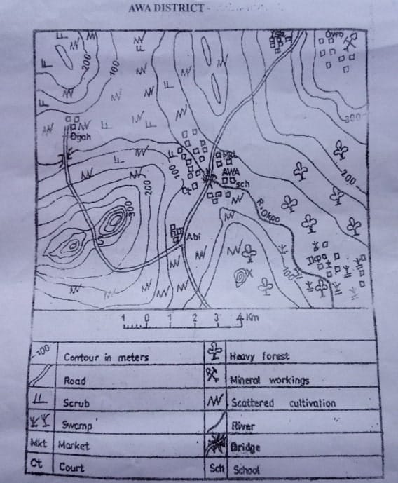
1. The scale of the map in Representative Fraction (RF) is
A. 1:300,00 B. 1:200,00 C. 1:100,00 D. 1:80,00
2. The feature marked X in the Southern part of the map is a
A. Ridge B. cuesta C. valley D. knoll
3. What is the relief in the space marked S
A. Pass B. saddle C. col D. knoll
4. What is the main occupation of people of Owo
A. Farming B. mining C. fishing D. trading
5. Which of the following will most likely to do well around Ikpa settlement
A. Sorghum B. millet C. rice D. guinea corn
See also: Wesley Girls’ Integrated Science Question Bank (Objectives)
Paper 1: GSTS Geography mock questions
6. AWA settlement can be describe as
A. Mining settlement B. industrial settlement C. confluence settlement D. port settlement
7. Which of the following is likely to be an economic activity in the South Eastern part of the mapped area
A. Lumbering B. animal rearing C. mining D. wood carving
8. Though what mode of transport will a visitor from Ikpa settlement arrive at AWA settlement
A. Air B. road C. Rail D. Water
9. What is bearing of Ise from Ogah
A. 10oC B. 40oC C. 70oC D. 210oC
10. AWA town performs educational function because
A. It is a university town
B. of the presence of school
C. it has a research institute
D. it has a school of radiation
Paper 1: GSTS Geography
11. Which of the following is at the centre of the solar system
A. The earth B. the moon C. the sun D. the stars
12. How many standard time zones will a country with a longitudinal extent of 120oC have
A. Six B. eight C. nine D. ten
13. The shape of the earth can be described as
A. Flat B. spherical C. circular D. spheroidal
14. Which latitudes mark the limits of the overhead sun’s apparent movement north and south of the equator
A. Horse lattitudes
B. Tropics of cancer and capricorn
C. Doldrums
D. Beneath the earth’s surface
15. Plutonic rocks are igneous rocks that have hardened
A. On the earth’s surface
B. On the top of volcanoes
C. In temperate seas
D. Beneath the earth’s surface
See also: Prempeh Integrated Science Question Bank (Objectives)
Paper 1: GSTS Geography mock questions
16. What relief feature is formed when magma cut across the layers of sedimentary rocks
A. Dyke B. Sill C. Batholiths D. Lava plateau
17. What is the name of the raised portion of fold mountains
A. Synclines B. Pediments C. Graben D. Anticlines
18. When magma intrudes into horizontal cracks in the bedrock, it forms
A. Dyke B. Sill C. Batholiths D. Lava plateau
19. Into what metamorphic rock is chalk and limestone change during the process of metamorphism
A. Slate B. Marble C. Quartzite D. Gneiss
20. In which of the following layers of the atmosphere does temperature decrease with altitude
A. Troposphere B. Ionosphere C. Thermospher D. Exosphere
Paper 1: GSTS mock questions
21. Which of the following features in the ocean basin is the Mariama Trench
A. A deep sea plain
B. A continental slope
C. A continental shelf
D. An ocean deep
22. Whis is the abyssal plain found
A. On the ocean floor
B. On submerged coastlands
C. In the middle course of a river
D. In limestone regions
23. What is the name of the permeable rock layer which lies between the layers of impermeable rock in an artesian basin
A. Oasis B. watershed C. aquifer D. channel
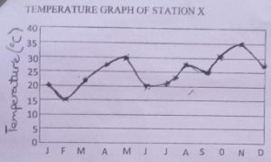
24. Which of the following months is hottest at station X
A. November B. May C. March D. January
25. The method used for illustration of the statistics for station X above is
A. Complex graph B. pie chart C. histogram D. simple line graph
See also: Presec Integrated Science Question Bank (objectives)
Paper 1: GSTS Geography mock questions
26. What is the annual range of temperature for station X.
A. 15oC B. 21oC C. 30oC D. 36oC
27. The range of temperature in coastal areas is smaller than that of inland area because
A. The sea has a moderating influence on coastal temperature
B. Coastal areas are constantly hotter than the inlands
C. Coastal area are drier
D. Rainfall along the coast is lower
28. The extension of the desert area that were originally not desert in called desert
A. Penetration B. encroahment C. movement D. invasion
29. The transfer of energy from one tropic level to another within an ecosystem is referred to as
A. Food chain B. carbon cycle C. nitrogen cycle D. ecosystem interaction
30. The cooling of a warm moist air current as it passes over a cold sea or land surface often causes
A. Hailstones B. fog C. sleet D. high tides
Paper 1: Geography
31. In what unit is relative humidity expressed
A. Percentages B. Degrees centrigade C. kilogram D. degrees fahrenheit
32. Which of the following refers to soil profile
A. The shape of the land
B. The vertical section of the soil
C. The mineral composition of the soil
D. The parent material component of the soil
33. ‘it is fine in texture, with small pore spaces and is poorly aerated’. This statement describes
A. Clayey soil B. Loamy soil C. Lateritic soil D. Sandy soil
34. ‘it is characterized by the presence of abundant grass with scattered trees’. This statement describes
A. Rainforest vegetation B. savanna vegetation C. temperature forest D. coniferious forest
35. What is an association or group of plants growing together in a particular habitat called
A. Vegetation B. botany C. biosphere D. lithospere
Paper 1: GSTS Geography mock questions
36. In which of the following regions will chemical weathering occur throughout the year
A. Mediterranean B. tropical continental C. equatorial D. temperature continental
37. The position of Africa from 37oN to 35oS of the equator makes it the most
A. Tropical of all the continent
B. Polar of all the continents
C. Temperate of all the continents
D. Sub-temperate of all the continents
38. Which of the following is a distinguishing feature of a rural settlement
A. Large aerial coverage
B. Many social amenities
C. Primary economic activities
D. People of different cultural backgrounds
39. The following are factors responsible for migration except
A. Natural disaster
B. Population pressure on land
C. Age of the natives
D. Changes in status
40. The busiest ocean trade route is the
A. Suez canal route
B. Panama canal route
C. Cape route
D. North atlantic route
Paper 1 questions
41. When the value of country’s exports equals the value of her imports, she has achieved
A. Balance of trade B. favourable trade C. barter trade D. world trade
42. Which of the following situations refer to optimum population
A. When the resources and population are in equilibrium
B. When the population far exceeds its resources
C. When the resources for the rural population is abundant
D. When the resources for the rural population is abundant
43. Which of the following countries has the highest population density
A. Mali B. North korea C. Java D. Malaysia
44. In which of the following industry type is copper commonly used a raw material
A. Chemical industry B. wood processing industry C. cement industry D. Electrical industry
45. Which of the following areas is the best location for cement industry
A. Near the market
B. At the source of power
C. Near the source of raw material
D. Where labour is abundant
Paper 1: GSTS Geography mock questions
46. In which of the following plants communities can oak, olive, cedar, laurel and rosemeary be commonly found
A. Mediterranean woodland B. tropical rainforest C. cool temperate forest D. tropical woodland
47. Which of the following cities is most important for gold mining in Africa
A. Jos B. Banjul C. Pretoria D. Johannesburg
48. The following are importance of gold mining in South Africa except
A. Generation of revenue
B. Collapse of the roof of the mines
C. Development of great cities
D. Provision of employment for people
49. Which of the following accounts for the high irrigation farming in the northern part of West Africa
A. Abundant plants for cultivation
B. Limited market for agricultural products
C. Inadequate rainfall
D. Good roads and adequate capital
50. On which river is the Victoria falls
A. Limpopo B. Vaal C. Zambezi D. Orange
Paper 2: GSTS mock
Section A.
Candidates are to answer at least one question from this section
1a. Table 1 below shows the population distribution and land area of five states of country ‘B’ in the year 2010.
Use the data to answer the questions that follow
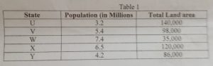
Calculate
i. Total population
ii. Total land area
iii. Population density of country ‘B’
b. Explain four factors that influence the distribution world human population
c. Outline three factors that cause increase in world human population
2a. Describe four factors that influence international trade
b. With specific examples, explain the role transportation play in world trade
c. Highligh two reasons for low volume of trade among West African countries
3a. List four industrial cities of North-Eastern USA
b. Outline five factors that favour the concentration of industries in north Eastern USA
b. Explain three characteristics of heavy industries
Section B: Home country (Ghana)
Answer at least one question from this question |GSTS geography mock questions
4a. Draw a sketch map of Ghana
On the map show and name
i. Latitude 6oN and 10oN
ii. Longitudes 1oE and 3oW
iii. Half Assini
b. Describe Ghana under the following headings
c. Location II. Position III. Size
5a. Draw a sketch map of Ghana
On your map show and name
i. Gambaga Escarpment
ii. Akuapim-Togo Ranges
iii. River Oti
iv. River Densu
v. Lake Volta
vii. River Ankobra
b. Describe any three characteristics of river in Ghana
c. Outline any three importance of rivers in Ghana
6a. Draw a sketch map of Ghana
On your map show and name
i. One area of low population density
ii. One are of high population density
iii. Tamale, kumasi, takoradi, Accra
a. Explain with examples, the factors that affect the distribution of population in Ghana
b. Outline three problems of high population density in one area shown on your map
Section C: Africa
Answer at least one question from this section | GSTS geography mock questions
7a. Draw a sketch map of West Africa
On your map show and name
i. Guinea highlands
ii. Jos plateau
iii. Adamawa highlands
iv. River niger
v. Kainji Lake
b. Highlight three importance of highligh regions in the development of West African countris
b. Explain any two problems highlands pose to development in West Africa
8a. Draw the map of Africa
On your map show and name
i. One area that records rainfall over 3,000,,
ii. One area that records rainfall less that 250mm
iii. One town in each of the areas shown in 8(a)(I) and (II)
a. Outline four negative effects of the tropical continental (cT) air mass in Africa
b. Describe two methods used for conserving water for agriculture in Africa
9a. Draw an outline map of Africa
On the map locate and name
i. One area noted for plantation farming
ii. One area noted for irrigation farming in the northern hemisphere
iii. One are noted for petroleum production
a. Identify three problems of petrochemical industries in Tropical African
b. Give two reason for irrigation farming in the Niger Valley
Paper 3: Elements of practical and physical geography
Geography mock questions: Answer question 1 and any 3 other questions.
1. Study the map extract provided on a scale of 1:50,000 and answer the question that follow
a. In your answer booklet, draw the outline of the area labelled ABCD to a new scale of 1:25,000
b. In your new outline insert and name
i. the first class road ii. ABURI and Kitease (Kitase) settlements
c. Calculate the areas of the map provided in kilometers square
d. state wo functions of ABURI
e. Describe the road network on the mapped area
2. The table below shows the population structure of country ‘Q’ in 2021.
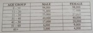
a. Using a scale of 1cm to represent 10,000 people represent the data by means of population Pyramid
b. State two advantages of population pyramid
c. State two alternative methods of representing the data
GSTS Geography mock questions
3a. What is river capture
b. With the aid of diagram, outline three conditions under which river capture can be formed
c. Describe any three differences between the upper course and the lower course of a river.
4a. Define weathering
b. Identify three factors that affect weathering
c. Describe any two process of chemical weathering
GSTS Geography mock questions
5a. Define the term mass wasting
b. Describe three causes of landslide
c. Highlight three effects of landslide
6a. What is a great cycle
b. Explain three characteristics of great cycle
c. Highlight three differences between longitudes and latitudes
GSTS Geography mock questions
7a. Define the term climate
b. Name the instrument used in measuring each of the following
i. temperature ii. pressure iii. rainfall iv. sunshine v. humidity
c. In what four ways is the study of weather important to Ghana
8a. What are environmental hazards
b. List three examples of environmental hazards
c. Identify five ways in which mankind contributes to environmental hazards
Post Disclaimer
The information contained in this post is for general information purposes only. The information is provided by Educative News and while we endeavour to keep the information up to date and correct, we make no representations or warranties of any kind, express or implied, about the completeness, accuracy, reliability, suitability or availability with respect to the website or the information, products, services, or related graphics contained on the post for any purpose.